
Best Apps for Crop Monitoring: 7 Tools Compared
Satellite platforms, aerial scouting and ground-level harvest tracking, side by side. What each one actually measures, who it suits, and where the gaps are for labor-intensive crops.
Schedule an Intro MeetingJump to a section
Crop Monitoring Means Two Different Things
Most buyers compare tools that are not actually solving the same problem.
1. Remote sensing — how the crop is doing
Satellite and aerial imagery, vegetation indices such as NDVI, weather data and soil moisture. These tools tell you where in a field the crop is stressed, and roughly why. Nearly every app marketed as "crop monitoring" sits in this group.
2. Ground truth — what actually happened in the field
Who picked what, how much, at what quality, at what labor cost, on which block and shift. Satellites cannot see any of this. For hand-picked crops it is usually the largest controllable cost on the farm.
Why it matters: a satellite platform can tell you a block is underperforming. It cannot tell you whether that block was picked by a short-handed crew, picked twice, or picked to a lower quality standard. If you grow berries, orchard fruit, vegetables or anything harvested by hand, you need both kinds of data — and most farms only buy the first.
Crop Monitoring Apps Compared
What each tool measures and the type of grower it fits best.
| Tool | What it monitors | Primary data source | Best suited to |
|---|---|---|---|
| EOSDA Crop Monitoring | Crop health, vegetation indices, weather, soil moisture, field zoning | Satellite | Growers wanting satellite analytics in one place |
| OneSoil | Field vegetation, zoning, variable-rate maps | Satellite | A no-cost starting point for satellite monitoring |
| Climate FieldView | Field data, planting and yield maps, equipment data | Machinery + satellite | Mechanised row-crop operations |
| Syngenta Cropwise | Plant health, agronomic recommendations, operations | Satellite + agronomy models | Large enterprise and cooperative farms |
| Taranis | Leaf-level pests, disease, nutrient deficiency | High-resolution aerial imagery + AI | Detailed agronomic scouting |
| Agrivi | Crop plans, tasks, field records, monitoring | Manual entry + satellite | Growers wanting management and monitoring together |
| PickApp | Picking volumes, worker output, attendance, quality, labor cost | In-field QR scanning by the crew | Labor-intensive, hand-picked crops |
Product descriptions reflect how each vendor positions its own platform. Capabilities and availability vary by country — check directly with the vendor before buying.
The 7 Crop Monitoring Tools
1EOSDA Crop Monitoring
A satellite-based precision agriculture platform that brings crop health, weather, crop rotation, field activity, elevation and soil moisture into a single view. It is built around near-real-time detection of stress — heat, cold, water, pests, weeds and disease pressure — across whole fields rather than sample points.
- Vegetation indices including NDVI, with historical field comparison
- Scouting tasks that can be assigned and tracked
- Weather data and field-level productivity maps
Best for: growers who want satellite analytics without sourcing and processing imagery themselves. EOSDA Crop Monitoring
2OneSoil
A field monitoring app offering free satellite maps for scouting, soil sampling and variable-rate application. It is one of the easiest ways to see satellite vegetation data for your fields without a procurement process, which makes it a common first step for growers new to remote sensing.
- Free satellite field maps and vegetation tracking
- Field zoning for variable-rate application
- Straightforward mobile and web interface
Best for: trying satellite monitoring at no cost before committing budget. OneSoil
3Climate FieldView (Bayer)
FieldView is the digital farming platform from Climate LLC, Bayer's digital arm. It collects, stores and analyses field data on one platform, with a strong emphasis on connecting machinery data to planting, fertility and crop protection decisions. Bayer reports the platform is available in 23 countries across more than 250 million subscribed acres.
- Planting, application and yield maps from equipment data
- Field-by-field performance analysis across seasons
- Broad machinery and data-partner integration
Best for: mechanised row-crop farms where most data comes off the equipment. Climate FieldView
4Syngenta Cropwise
Cropwise is Syngenta's digital platform, spanning several products including Cropwise Operations, which provides real-time satellite monitoring of plant health and field conditions. Syngenta reports the platform covers more than 70 million hectares across over 30 countries. It incorporates the technology Syngenta acquired with Cropio in 2019, so growers researching "Cropio" will now be pointed here.
- Satellite plant-health monitoring across large areas
- Agronomic recommendations and product selection tools
- Operations and field-work management modules
Best for: enterprise farms, cooperatives and agribusinesses operating at scale. Syngenta Cropwise
5Taranis
Taranis takes a different route to the satellite platforms: very high resolution aerial imagery combined with AI to identify problems at leaf level. That means early detection of specific pests, diseases and nutrient deficiencies that a satellite pixel simply cannot resolve.
- Leaf-level imagery rather than field-average indices
- AI identification of pests, disease and deficiency
- Agronomic insight aimed at in-season intervention
Best for: operations that need scouting detail beyond what satellites provide. Taranis
6Agrivi
Agrivi is a farm management platform that combines crop planning, task management and field record keeping with monitoring features. It suits growers who would rather run planning and monitoring in one system than stitch a management tool to a separate imagery product.
- Crop plans and season-long task management
- Field records and input tracking for compliance
- Monitoring alongside the management workflow
Best for: growers consolidating planning and monitoring in one platform. Agrivi
7PickApp — monitoring the harvest, not the canopy
PickApp is deliberately not a satellite platform. It measures what happens on the ground during picking: volumes per worker, per block and per shift, attendance, quality results and the real labor cost behind them. Workers scan a QR code when they start and finish, so the data is captured as the work happens rather than typed up afterwards.
- Real-time picking volumes and per-worker productivity
- Attendance and labor cost by block, shift and crew
- Quality control linked back to the individual picker
- Works offline in the field and supports multilingual crews
Growers using PickApp see 18–20% labor cost reduction and 7.5–9% quality improvement, with implementation typically taking 2–3 days. It is in use on farms across 4 continents. See the numbers in our success stories.
Best for: berries, orchard fruit, vegetables and any crop where people, not machines, bring in the harvest. Explore PickApp farm management software.
How to Choose a Crop Monitoring App
Four questions that narrow the list quickly.
What is your biggest cost?
If it is inputs and machinery, a satellite or equipment platform pays back fastest. If it is labor — typical for hand-picked crops — monitoring the canopy will not touch your largest line item.
How large are your blocks?
Satellite resolution works well across large uniform fields. On small, mixed or heavily canopied blocks the imagery gets much less useful, and aerial or ground data matters more.
Who enters the data?
Any tool that depends on someone typing up sheets in the evening will decay within a season. Capture has to happen where the work happens, or the data stops arriving.
Does it work without signal?
Fields rarely have reliable connectivity. Check that the app stores data offline and syncs later, rather than failing silently mid-shift.
Satellites Cannot See Your Crew
Every platform on this list except PickApp answers the same question: how is the crop growing? That is a genuinely useful question, and if you grow broad-acre crops it may be the only one you need.
But on a berry farm or in an orchard, labor is routinely the largest controllable cost of the season, and none of it appears in satellite imagery. Picking rates per worker, hours actually worked, quality by picker, cost per kilo per block — that data either gets captured in the field as the work happens, or it does not exist.
The two are complements, not competitors. Use remote sensing to decide where to send people. Use harvest tracking to know what it cost when they got there and what came back.
Frequently Asked Questions
See What Your Harvest Is Actually Costing You
Satellite data shows you the crop. PickApp shows you the picking — volumes, workers, quality and cost, in real time, on any phone.
Schedule an Intro MeetingMost farms are up and running in 2–3 days.
Get it on

PickApp from
Anywhere


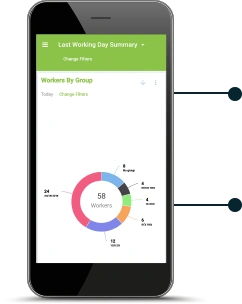
Real-Time Management
Any Mobile Device
Solutions
Yearly Crops (Vegetables)
Structural investments and year-round work must produce high yields. Use PickApp to optimize your growth.

Seasonal Crops
Picking season is here and time is of the essence. PickApp helps you make the most out of both land and labor.

Open Fields
High-quality produce and efficient harvest define your profits. Use PickApp to live up to your standards.

Large Farms
Whether you are an enterprise farm, a cooperative, a packing house or a brand, PickApp helps you regain control.


View PickApp in Action
Watch the true prowess of PickApp's farming app robust solution.
Labor-Cost Savings Estimator
Management
Tools
PickApp uses advanced
analytics, automation and Big
Data to help farmers increase
labor productivity and enhance produce quality.






All-in-One Farm Management Software
Labour Tracking App
- Scan-&-go piece-rate logs
- H-2A & overtime compliance
- Exports to payroll & QuickBooks
Harvest Traceability App
- QR / RFID bin tags
- GLOBAL G.A.P. IDA ready
- 99 % scan accuracy
Quality Control App
- Real-time defect grades
- Pack-out analytics by picker & block
- Pallet release reports
Built for Compliance
PickApp aligns with the standards that matter most to growers, packers and buyers worldwide.
